
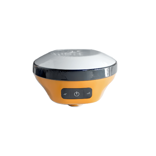
Overview
This High Precision Hi TARGET Surveying Instrument has 3 seconds start time, 1 Hz to 20 Hz positioning output frequency and Linux operating system.
Features
- Advanced RTK engine
- Full-constellation tracking
- Web UI
- Built in radio
- NFC
- Compatibility with third party software
- LED Indicator Light: Satellite lights, signal lights, power lights
- Web Ui , Built-in WEB page to realize receiver setting and status check
Technical Specifications
| Output Format | ASCII: NMEA-0183, binary code |
| Positioning Output Frequency | 1 Hz to 20 Hz |
| Static Data Format | GNS, Rinex dual format static data |
| Difference Format | CMR, RTCM2.X, RTCM3.0, RTCM3.2 |
| Network Mode | VRS, FKP, MAC; support NTRIP protocol |
| Operating System | Linux operating system |
| Start Time | 3 seconds |
| Data Storage | Built-in 8 GB ROM, supports automatic storage of static data |
| RTK Positioning Accuracy | Plane: ± (0.32 in + 0.04 in x 0.39 in – 0.24 in) ± (8 mm +1 mm × 10 mm – 6 mm D) (D is the distance between the measured points) Elevation: ± (0.59 in + 0.04 in x 0.39 in – 0.24 in D) ± (15 mm+1 mm×10 mm-6 mm D) (D is the distance between the measured points |
| Static Positioning Accuracy | Plane: ± (0.10 in + 0.02 in x 0.39 in – 0.24 in D) ± (2.5 mm+0.5 mm×10 mm-6 mm D) (D is the distance between the measured points) Elevation: ± (0.20 in + 0.02 in x 0.39 in – 0.24 in D) ± (5 mm+0.5 mm×10 mm-6 mm D) (D is the distance between the measured points) |
| DGPS Positioning Accuracy | Plane accuracy: ±0.25m+1ppm; elevation accuracy: ±0.50m+1ppm |
| SBAS Positioning Accuracy | 0.5 m |
| Initialization Time | <10 seconds |
| Initialization Reliability | >99.99 % |
| I/O Port | USB Type-C interface, SMA in |
| Built-in 4G Network Communication | Built-in eSIM4 card, including 3 years Internet access fee, you can connect to the Internet after power on |
| Wifi Communication | 802.11 a/b/g/n access point and client mode, can provide WiFi hotspot service |
| Communication | ® 4.2/2.1+EDR, 2.4 GHz |
| Electronic Bubble | Realize smart alignment |
| Tilt Measurement | Built-in high-precision inertial navigation, automatic attitude compensation, 0.32 in + 0.03 in (8 mm+0.7 mm/°tilt) (accuracy within 30°<2.5 cm) |
| Button | A power button |
| Advanced Features | OTG function, NFC IGRS, WebUI interaction, U disk firmware upgrade |
| Smart Application | Smart base station, smart voice, function self-check, smart CORS |
| Remote Service | News push, online upgrade, remote control |
| Cloud Service | Equipment management, location services, collaborative operations, data analysis |
| Host Battery | Built-in high-capacity lithium battery 6800 mAh/7.4 V, network mobile station working time is more than 10 hours |
| External Power Supply | Support USB port charging and external power supply |
| Power Consumption | 4.2 W |
| Dustproof And Waterproof | IP68 |
| Anti-fall | Resistance to natural drop of 2m high measuring rod |
| Relative Humidity | 100% non-condensing |
| Operating Temperature | -22 °F to 158 °F (-30 ℃ to +70 ℃) |
| Storage Temperature | -40 °F to 176 °F (-40 ℃~+80 ℃) |
| Size | Φ 5.20 in x 2.64 in (132 mm x 67 mm) |
| Weight | ≤ 1.81 lb. (820 g) |


Reviews
There are no reviews yet.